
Posted on 9 November 2020 by Jesica Murcia López, Centre for Environmental and Climate Research (CEC) and invited guest Torsten Krause, Lund University Centre for Sustainability Studies (LUCSUS), Lund University.
The views expressed in this publication are those of the authors and do not necessarily represent those of the Agenda 2030 Graduate School or Lund University. The present document is being issued without formal editing.
The Amazon rainforests extend over a large swath of South America and are one of the world’s most important bioregions regarding its biological, social, and cultural diversity and the ecosystem services it providesto people. Many of us associate the Amazon basin as an expanse of primary forests stretching over an area of 7 million km2 making it the largest rainforest on earth spread out over nine countries: Brazil, Colombia, Peru, Venezuela, Ecuador, Bolivia, Guyana, Surinam, and French Guyana. But the Amazon basin also, contains floodplains forests, swamps, savannas, and numerous river systems. The Amazon basin is a world of its own which is biologically and culturally mega diverse. It is globally important because the forests store vast amounts of carbon and stabilize the global climate and they are home to the numerous species of flora and fauna, containing one in 10 species known to science. Approximately 40.000 plant species (some of which have huge potential for western medicine), 3.000 species of freshwater fish, 1.200 species of bird, and about 400 species of mammals, reptiles and amphibians have been described so far. Around 30 million people live in the Amazon region and an estimated 9% (2.7 million) belong to 350 different ethnic groups about 240 languages. Regionally, the Amazon forests generate the rains on which for example the agricultural industry in Brazil depends on. And for the thousands of local communities, the forests and rivers of the Amazon region are their supermarket, providing fish, meat, fruit, nuts, fibre, shelter and a large number of important intangible benefits and a source of spiritual value.
Deforestation and degradation of the Amazon’s forests has already transformed a large share of the region, primarily driven by land clearing for agricultural development. While we have data on deforestation from using satellite images, forest degradation (e.g. selective logging) is more difficult to obtain but estimated to be widespread and surpass deforestation in the Brazilian Amazon for instance. The projection and scenarios paint a bleak picture on how the continuous deforestation will affect the global climate and leading to a tipping point in the Amazon region that leads to conditions which will further threaten the remaining forests. More severe dry seasons will increase the risks of fires and eventually transform the forests, particularly in the southern and eastern parts of the Amazon region to a savannah.
Although the destruction of tropical forests has received worldwide attention for several decades already, the Brazilian Amazon region still has the world’s highest absolute rates of deforestation and fragmentation. Soya plantations and cattle ranching for international exports that transformed the Cerrado’s (a vast tropical savanna) and Pantanal (world’s largest tropical wetland and flooded grassland area) in Brazil are increasingly moving into the Amazon region across the nine countries that constitute the Amazon, is threatened. But reliable information on deforestation from other countries, like the Colombian or Venezuelan Amazonia, is often scarce or non-existent. The human pressure on forest land, foremost agriculture as well as mining, oil extraction, illegal crops, and road development, is a threat to the Amazon’s forests everywhere.
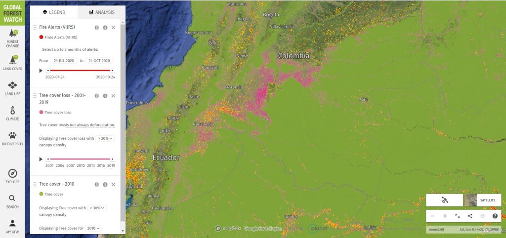
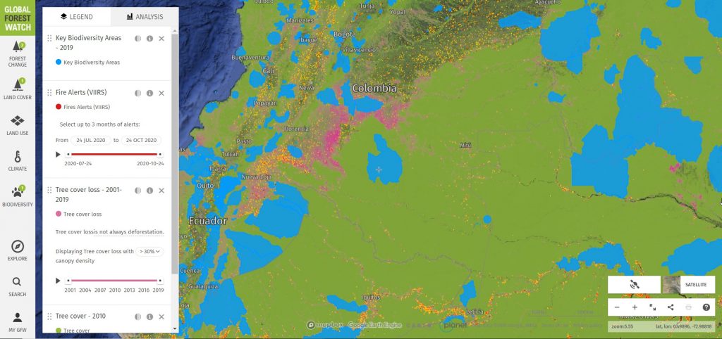
To explain how human intervention encroaches into the Amazon’s forests, map (a) shows the number of fire alerts in yellow and red colours and the forest loss areas in pink reported from January 2015 until 03 October 2020. The data set is created by the GLAD (Global Land Analysis & Discovery) lab at the University of Maryland and supported by Global Forest Watch, which is the first Landsat-based alert system for tree cover loss. The Key Biodiversity Areas (KBA in blue colors) in map (b) represent sites that contribute significantly to the global persistence of biodiversity, in terrestrial, freshwater, and marine ecosystems.
These maps reveal how areas of high biodiversity value are threatened by human encroachment. In Colombia, this is often also due to land-use conflicts between farmers, indigenous groups and the government, which culminate in large-scale illegal land-grabbing by some powerful farmers who seek to extend their land holdings. Forest degradation and deforestation are inevitable consequence of these land use conflicts.
The most recent estimate of total accumulated deforestation between pre-1970 and 2018 for example in the Brazilian Amazon (which accounts for 60% of the Amazon basin) is 17%. Concerning the remaining Amazon countries, most recent scientific evidence shows that since 2012 overall rates declined in Peru and Bolivia, stabilized in Ecuador, but increased in Colombia. The latest report from the national Institute of Hydrology, Meteorology and Environmental Studies IDEAM(March 2020) shows that aproximately 68,3% of deforestation in Colombia is concentrated in the Amazonas.
In particular, the main direct causes of deforestation in the Colombian Amazon are expansion of the agricultural frontier, illegal extraction of minerals, infrastructure expansion, timber extraction and forest fires. However, it is important to keep in mind that these direct causes of deforestation are driven by social, political, economic, technological, and cultural factors, which influence the decisions of the actors involved in deforestation. Among these underlying causes of deforestation are technological and economic factors (e.g. markets of land, illegal economies, costs of production and consumption and state incentives), political and institutional factors (e.g., sectoral policies, lack of institutional presence), cultural factors (e.g., worldviews, local customs and ancestral practices, and education), and demographic factors (e.g., population growth and migration).
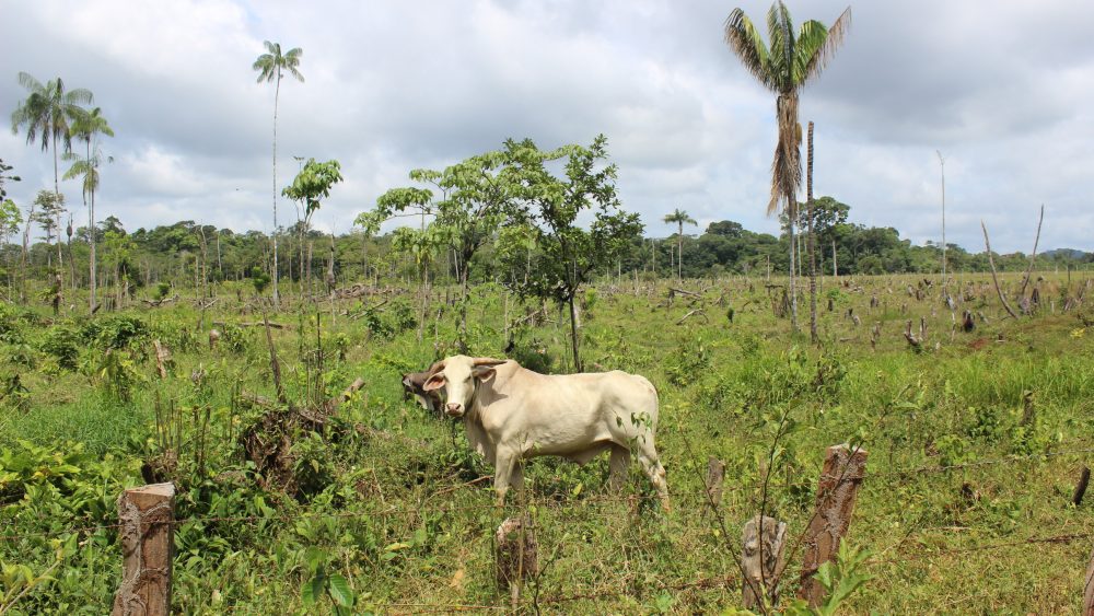
The impact of forest clearance to open pastures range from local (e.g., formation of ‘new’ socio-economic models) to global (carbon emissions). The link between deforestation and cattle ranching is strongest in Latin America and it causes irreversible environmental damages for tropical rainforests (e.g. biodiversity loss, soil degradation, and water pollution). As an attempt to lessen the curve of deforestation the goal of the current government of president Iván Duque is to plant 180 million of trees in 2022, where about 24,7 million were planted in 2019 and approximately 60 million in 2020 so far. This government still needs to plant 120 million for the next two years. Yet, the question whether this will actually decrease deforestation and effectively reforest former forest lands is up for debate.
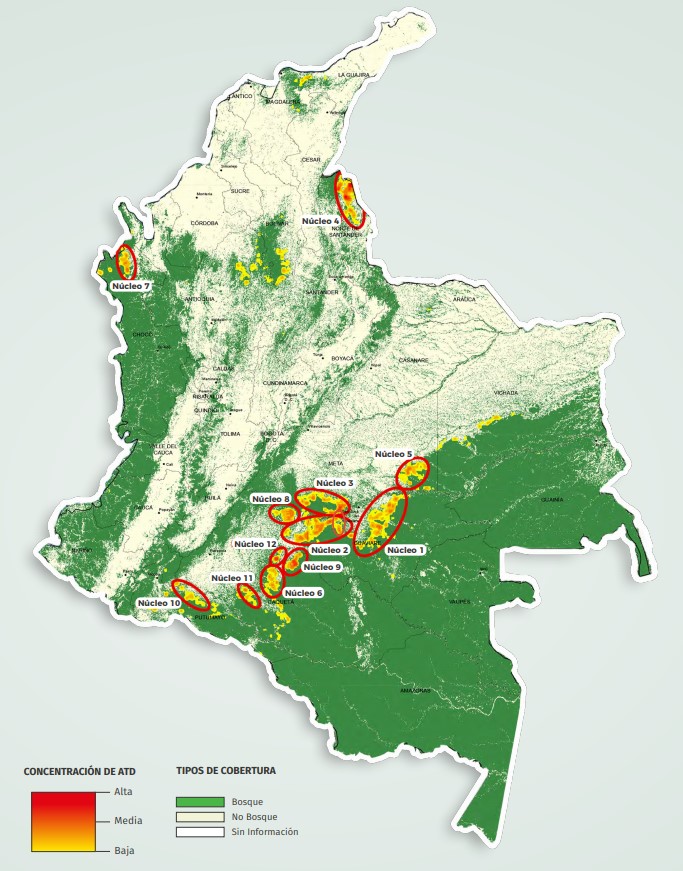
Colombia endured five decades of armed conflict with the Revolutionary Armed Forces of Colombia (FARC) until a peace agreement was signed in 2016. Followed by a pattern of deep-rooted unplanned land occupation by thousands of internal displaced people, FARC ex-combatants and national as well as international investors seeking to reap the benefits of the pathway towards peace. The transition towards peace has created many new challenges for Colombia, tackling the deforestation crisis that currently rips through the Amazon region is one of the largest one. The map (c) shows the latest update of deforestation hotspots in Colombia (as per June 2020) identified by the IDEAM.
The Colombian government has been working for the last eight years on a strategy to halt deforestation and forest degradation, including the participation of communities, international cooperation, academia, labour unions, institutions, and society. The strategy called “Forest territories for Life” (Bosques Territorios de Vida, in Spanish) is a commitment to enhance the social, cultural, and economic value of all forest ecosystems in the country, with special attention to the Amazonas. The design of such strategy has international support and resources for approximately 366 million dollars, mostly contributed by Norway, Germany, and the United Kingdom on behalf of the Sustainable Colombia Fund.
Nonetheless, regardless of the international support, land grabbing and land speculation (the contentious issue of large-scale land acquisitions) continues to be the main cause of deforestation in the Colombian Amazon. Yet, the region has been previously affected for many years by activities such as the extraction of minerals (legal and illegal) and cultivation of coca for illicit use, which became important catalysers of the deforestation process already since the 1980s. Most recently when the Colombian government and the FARC signed a peace agreement in 2016, the land grab was followed by a fast opening of pastures for cattle grazing and cattle ranching for domestic meat and milk consumption. The main consequences are deprivation of land of local communities and creation of environmental problems through intensive agriculture (livestock) and increased water demand.
Moreover, there are in total eleven protected areas* in the Colombian Amazon. As defined by the International Union for Conservation of Nature (UICN) a protected area is a clearly defined geographical space, recognised, dedicated and managed, through legal or other effective means, to achieve the long term conservation of nature with associated ecosystem services and cultural values.
Four of these reserves, the natural reserve Nukak, Serranía de La Macarena National Natural Park, Tinigua National Natural Park and the Serranía del Chiribiquete National Park (UNESCO) have been critically affected by deforestation since the post-conflict (when FARC guerrillas retired from the armed conflict in 2016). These protected areas are in the north west of the Colombian Amazon, where the Andes mountain range meets with the Amazon and the Orinoco biomes in the Guiana Shield, a 1.7 billion-year-old Precambrian geological formation in northeast South America. The area is known as the Piedemonte Amazónico (Amazonian foothills, in English). More importantly, 67,4% of the area affected by deforestation processes is concentrated in the Sierra de la Macarena (41,7%) and Tinigua (25,7%). The natural reserve Nukak has high rates of deforestation compromising the territories of some indigenous communities living in voluntary isolation. At the Chiribiquete National Park deforestation is entering from the north-western part of the park. The main drivers of deforestation in this “biological corridor” formed by the four protected areas in this part of the Colombian Amazon, are the extensive cattle ranching with one cow per hectare selective logging, illegal crops, pastures, and land grabbing.
The challenging situation with deforestation followed by degradation in the Colombian Amazon is complex and requires action from different actors of the society. The solutions and pathways to reduce current rates towards the “zero-deforestation” level, are many. Some examples include, communitarian forestry, agroforestry, diet shifts and consumers behaviour, local businesses focusing on local products for food, informed ecotourism, and in some cases enhancement of silvopastoral systems outside the Amazonian territory.
So, is Colombia reaching zero-deforestation goals in 2020? Looking at the numbers, it is obvious that this is impossible. Could be possible to do it by 2030? Maybe.
References citations added as links straight into the text
- Rice, J., V. Rodríguez Osuna, M. E. Zaccagnini, E. Bennet, D. Buddo, N. Estrada-Carmona, K. Garbach, N. Vogt, and M. P. Barral. 2018. Setting the scene. Pages 1-52 in J. Rice, C. S. Seixas, M. E. Zaccagnini, M. Bedoya-Gaitán, and N. Valderrama, editors. The regional assessment report on biodiversity and ecosystem services for the Americas. Secretariat of the Intergovernmental Science-Policy Platform on Biodiversity and Ecosystem Services, Bonn, Germany.
- Saatchi, S. S., R. A. Houghton, R. C. dos Santos Alvalá, J. V. Soares, and Y. Yu. 2007. Distribution of aboveground live biomass in the Amazon basin. Global Change Biology 13 (4):816-837. https://doi.org/10.1111/j.1365-2486.2007.01323.x
- https://www.worldwildlife.org/stories/what-animals-live-in-the-amazon-and-8-other-amazon-facts
- World Wide Fund for Nature (WWF) 2020. Living Amazon Initiative. Protected areas and Indigenous Territories, Knowledge Hub. Consulted 1 October 2020. https://wwf.panda.org/knowledge_hub/where_we_work/amazon/vision_amazon/living_amazon_initiative222/protected_areas_and_indigenous_territories/
- Ruiz Agudelo, C. A., N. Mazzeo, I. Díaz, M. P. Barral, G. Piñeiro, I. Gadino, I. Roche, and R. Acuña. 2020. Land use planning in the Amazon basin: challenges from resilience thinking. Ecology and Society 25(1):8. https://doi.org/10.5751/ES-11352-250108
- Laurance, W. F., Albernaz, K.M., Schroth, G., Fearnside, P. M., Bergen, S., Venticinque, E.M. and Da Costa, C. 2002. Predictors of deforestation in the Brazilian Amazon. Journal of Biogeography 29 (5): 737-748. https://doi.org/10.1046/j.1365-2699.2002.00721.x
- IUCN – The International Union for Conservation of Nature (2016). A Global Standard for the Identification of Key Biodiversity Areas, Version 1.0. First edition. Gland, Switzerland: IUCN.
- Coca-castro, A., Reymondin, L., Bellfield, H., Hyman, G., 2013. Land Use Status and Trends in Amazonia, Terra-i.
- INPE, 2019. PRODES: Monitoramento do Desmatamento da Floresta Amazônica Brasileira por Satélite [WWW Document]. INPE, Coord. Obs. da Terra. URL http://www.obt.inpe.br/OBT/assuntos/programas/amazonia/prodes (accessed July 10, 2020).
- Hansen, M.C., Potapov, P. V, Moore, R., Hancher, M., Turubanova, S.A., Tyukavina, A., Thau, D., Stehman, S. V, Goetz, S.J., Loveland, T.R., Kommareddy, A., Egorov, A., Chini, L., Justice, C.O., Townshend, J.R.G. 2013. High-resolution global maps of 21st-century forest cover change. Science 342, 850–3. https://doi.org/10.1126/science.1244693
- Rosales, M. no year. Livestock Information, Sector Analysis and Policy Branch Animal Production and Health Division. FAO. http://www.fao.org/3/a-a0262e.pdf
- El Tiempo newspaper. 2020. Gobierno de Duque se comprometió a plantar 180 millones de árboles. https://www.eltiempo.com/vida/medio-ambiente/gobierno-de-duque-se-comprometio-a-plantar-180-millones-de-arboles-454428
- Moloney, A. 2019. Colombia’s Amazon forest gets boost with $366 million protection fund. https://www.reuters.com/article/us-colombia-forests-climate-trfn-idUSKBN1YF2BD
- Boletín de Detección Temprana de Deforestación (DT-D) Instituto de Hidrología, Meteorología y Estudios Ambientales (Ideam) Subdirección de Ecosistemas e Información Ambiental. Sistema de Monitoreo de Bosques y Carbono (SMByC). http://documentacion.ideam.gov.co/openbiblio/bvirtual/023891/22BOLETIN.pdf
- Bosques Territorios de Vida- Estrategia Integral de control a la deforestación y Gestión de los Bosques. 2018. Ministerio de Medio Ambiente de Colombia e Instituto de Hidrología, Meteorología y Estudios Ambientales (IDEAM). https://www.unredd.net/documents/un-redd-partner-countries-181/latin-america-the-caribbean-334/colombia-706/16790-bosques-territorios-de-vida-estrategia-integral-de-control-a-la-deforestacion-y-gestion-de-los-bosques.html